Source: cloutnews.com
The Chinese strategy of mass surveillance has, may be, achieved one of the greatest tangible results of the COVID-19 threat so far.
Singapore, Israel and China, though pressing the delicate button of the data protection regulation, have implemented strategies of controlled and monitored containment through advanced digital systems, such as drones and data mining tools, supported by applications installed in the mobile devices of the population, in order to track the population movements in quarantine times.
Tracking the path of the virus that makes its way from man to man is perhaps one of the keys to solving the intricate puzzle of the pandemic management, a management that requires fully quantitative methods of analysis and prevention, as well as the application of mathematical and statistical models that, however, if not supported by the right amount of data to be taken into analysis, cannot be correctly implemented and risk to provide partially (or totally) wrong answers.
In the same way, in Italy there are some technological proposals, that would require both technical-operational and regulatory screening, in view of what could, for some, be seen as a potential violation of the privacy rights, though their purposes would be the exclusive safeguard of the community.
«Singula», How It Works
One of the most accredited (perhaps the most accredited) at the moment, for simplicity of use and functionality of the process (in fact, you only need to download and identify yourself through your fiscal code), is the proposal of the Milan-based team led by the economist and innovation expert Giuseppe Signorelli, of Sicilian origin, who immediately saw digitalisation as the solution to this complex plot of limiting the spread of contagion.
The problem is of quantitative kind, «If you do not track the virus through the collection of individual data, the timeline of the containment strategy implemented by our country will be much longer», Signorelli reports.
The application is called «Singula» (from the Latin «Individual») and works as described from here on.
The first step, as anticipated, is the personal identification through the individual fiscal code.
From the moment of activation, the application makes a recording of the user’s position every exact 30 minutes using the smartphone GPS, and saves the positioning data in an internal database, accessible only through the owner’s smartphone.
The data is not shared with anyone, except with the express consent of the owner.
The application records the 48 daily positions (one every 30 minutes) and stores them for a period of time of 14 days (incubation time, even latent, of COVID-19). Every day, the data for the fifteenth day prior is deleted.
All positioning data are accessible from the owner’s smartphone and can be requested by the Civil Protection Department everytime:
– It is suspected that the owner had contacts with a virus carrier, in order to see, by cross-referencing the owner’s data with the data of the carrier, whether the two may actually had contacts;
– A new carrier is discovered, in order to track this carrier’s movements in the previous days and find, through crossreferencing his movement data with the movement data of other users, potential other infected persons, thus “drawing” the viral path.
The strategy is clearly aimed at isolating the virus by isolating its carriers, and thus reducing the timeline of the containment policy implemented by our government.
If, hypothetically, it were decided to increase the number of swabs, it would be logical to use the positioning data thus detected and start the swabs from the areas where carriers of the virus have passed or have spent most of their time, thus increasing the probability of finding, through the new swabs, new infected persons and isolate them.
«The effectiveness of the system is obviously directly proportional to the number of people using the application», Signorelli reports.
Ideally, if the application were mandatory for every Italian, it would be possible to have the amount of data to potentially isolate the virus almost completely and reduce the infection exponentially.
2.0 Geo-localisation Database
Through the application it is possible to access a map that geo-localizes the so-called «red zones» («hotspots»), i.e. the areas where a certain number (more or less large, depending on the size of the bubble) of contagions had occurred, on a local and national scale.
The data of the zones at risk are put into the application database by the application management team, which draws information from public sources, or directly from the Civil Protection Department for a more accurate report.
The purpose is clear, allow the population to know which areas of their city are most affected, and thus measure their choices regarding their «exits for necessity» in terms of risk of contagion.
The idea is that red zones should be discarded by those who were thinking to go there to carry out their necessary activities, preferring instead zones with lower levels of risk.
By scrolling down the page, in the same section, is reported the daily COVID-19 bulletin from the Civil Protection
3.0 «Red Zones» Database
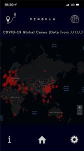
Other feature of the application is the reporting of certified information on the virus spread on a global scale.
Graphical and numerical reports are presented, as well as updated statistics on the spread, the mortality and the recovery from COVID-19.
The data source is the daily monitoring report from the Johns Hopkins University, Baltimore (USA).
4.0 Global Analysis COVID-19 (Source J.H.U.)
Lastly, among the application settings, is reported the privacy policy and are described the data encryption mechanisms for the user maximum safety.
The same page also lists the regional emergency numbers activated specifically for COVID-19 and provides the possibility to report an hotspot, even a restricted area at risk of contagion, or any information that may be useful to the Civil Protection Department to limit the spread.
